


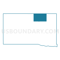
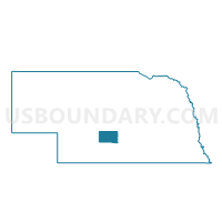
Kennebec Precinct, Dawson County, Nebraska
About
Outline

Summary
| Unique Area Identifier | 612707 |
| Name | Kennebec Precinct |
| County | Dawson County |
| State | Nebraska |
| Area (square miles) | 59.34 |
| Land Area (square miles) | 59.34 |
| Water Area (square miles) | 0.00 |
| % of Land Area | 100.00 |
| % of Water Area | 0.00 |
| Latitude of the Internal Point | 41.00330220 |
| Longtitude of the Internal Point | -99.67236770 |
Maps

Graphs
Select a template below for downloading or customizing gragh for Kennebec Precinct, Dawson County, Nebraska


Neighbors
Neighoring Voting District (by Name) Neighboring Voting District on the Map
- Coyote Precinct, Dawson County, NE
- Gillan Precinct, Dawson County, NE
- Loup Precinct, Custer County, NE
- Wood River Precinct, Custer County, NE
- Woodriver Precinct, Dawson County, NE
Top 10 Neighboring County Subdivision (by Population) Neighboring County Subdivision on the Map
- Coyote precinct, Dawson County, NE (550)
- Gillan precinct, Dawson County, NE (475)
- Wood River precinct, Dawson County, NE (459)
- Wood River township, Custer County, NE (326)
- Kennebec precinct, Dawson County, NE (183)
- Loup township, Custer County, NE (129)
Top 10 Neighboring Place (by Population) Neighboring Place on the Map
Top 10 Neighboring Unified School District (by Population) Neighboring Unified School District on the Map
- Lexington Public Schools, NE (12,327)
- Cozad City Schools, NE (5,227)
- Broken Bow Public Schools, NE (4,934)
- Callaway Public Schools, NE (1,294)
- Sumner-Eddyville-Miller Schools, NE (947)